
Gifford and Madre Fire Burn Scar Information


Virtual Community Meeting - Presentation
We hosted a virtual community meeting on November 24, 2025 to share information about the Gifford and Madre Fire Burn Scars and answer questions from the public. Below is the presentation for residents who were unable to attend.
Questions Received During the Meeting
| 1. Has there been any discussion within the County to clear creeks and riverbeds before more storms to allow for debris to flow. There is still around 4ft of debris in the Salinas River from the 2023 storms. |
| Yes, there has been internal discussion on this topic. County Public Works can only remove material within their right away. Some areas require getting authority from other government agencies. Property owners are encourage to visit Public Work’s Creek Care Guidance for more information about what they can do related to creeks and streams on their property: https://www.slocounty.ca.gov/departments/public-works/our-divisions/water-information-directory/creek-care-guidance |
| 2. It is my understanding that Public Works has the authority to clear creek beds 80ft on either side of a county-maintained bridge. Is that correct? |
| Public Work’s right of way varies depending on the location. |
| 3. Is there anyone within the County who can liaison with CalFire to see that Mitigation measures can be taken under their emergency authority? |
|
Cal Fire is not on the call this evening, but we will reach out and ask them about this and post here when we get more information. Generally speaking, there is work that can take place by response agencies as emergency work but it is limited in scope. |
Gifford Debris Flow Area - Are You Impacted?
Put your address in the blue "Find address or place" box at the top of the map to determine if you are within the Gifford Debris Flow Area.
The Gifford Debris Flow Area is made up of the following zones:
| LPZ Zones | SLC Zones |
| LPF-009 | SLC-222 |
| LPF-010 | SLC-223 |
| LPF-011 | SLC-239 |
| LPF-012 | SLC-261 |
| LPF-013 | SLC-262 |
| LPF-014 | SLC-263 |
| LPF-015 | SLC-297 |
| LPF-016 | SLC-334B |
| LPF-017 | SLC-336 |
| LPF-018 | SLC-337 |
| LPF-019 |
Please note, if protective actions are required, they will be made for the entire Gifford Debris Flow Area.
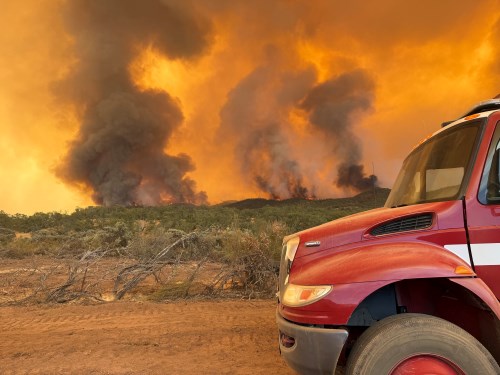
What is a Burn Scar?
A recent wildfire will have lasting effects on the landscape and create an increased risk of flooding for years to come, particularly in the first two years after the wildfire. Locations downhill and downstream from burned areas are very susceptible to flash flooding and debris flows, especially near steep terrain. Rainfall that would normally be absorbed will run off extremely quickly after a wildfire, as burned soil can be as water-repellant as pavement.
What is a Debris Flow?
Debris flows are fast-moving, damaging and potentially deadly landslides. They are powerful mixtures of mud, rocks, boulders, entire trees - and sometimes, homes or vehicles. You'll often hear "debris flows" called "mudslides" or "mudflows." Many people use the terms interchangeably, but to scientists, each is a different kind of landslide and debris flows are the most powerful and dangerous of the three. A state WERT came to the burn scar to provide local agencies information regarding debris flow thresholds and likelihood.
National Weather Service Debris Flow Fact Sheet
National Weather Service Flash Flood and Debris Flow Survival Guide
What's a WERT?
From the WERT website: California Watershed Emergency Response Teams (WERTs) help communities prepare after wildfire by rapidly documenting and communicating post-fire risks to life and property posed by debris flow, flood, and rock fall hazards. The WERT response is led by the California Department of Forestry and Fire Protection (CAL FIRE) and co-led by the California Geological Survey (Department of Conservation).
The California Watershed Emergency Response Team (WERT) has identified Values at Risk (VARs), which are values or resources at risk of damage or loss by post-wildfire geologic and/or hydrologic hazards for the burn scars. County officials also worked with the WERT to identify Secondary VARs, which are areas outside of the burn scar that are also at risk for debris flow. Residents identified and in close proximity have been contacted by mail.
WERT Reports and Data for Gifford Fire
Rain Intensity Information
Rain Intensity Thresholds
Debris flow thresholds (when debris flow may occur) determined by the WERT for the Gifford Burn Scar are:
- .35" or greater in 15 minutes
- .50" or greater in 30 minutes
- .70" or greater in 60 minutes
National Weather Service Forecasting Information
How does the NWS forecast storms?
NWS Oxnard/Los Angeles Forecasts
Protective Actions
The County does not plan to issue protective actions - Evacuation Warning, Evacuation Order or Shelter-in-Place - in the Gifford or Madre Burn Scar areas during normal winter rain / storms.
Protective Actions will only be issued in the event of severe or life threatening storms based upon either information received via forecast by the NWS or if an event occurs without notice in the area with the potential to threaten lives.
However, even if protective actions are not issued, residents are encouraged to leave BEFORE the rain begins if weather forecast or conditions make them uncomfortable or extra assistance would be required to leave. If debris flows occur and roads are inaccessible or destroyed, residents may be stuck in their homes until responders can safely deal with repairs.
How Will You Be Alerted?
When the National Weather Service forecasts a significant rain event, the County will notify residents in the Gifford Debris Flow Area via AlertSLO. It is VERY important that residents in the area sign up for these alerts so that emergency officials can communicate this information directly to them.
How to Get Signed Up
If you are not signed up to receive messages for the burn scar areas, please visit AlertSLO.org today and select the group titled "Gifford and Madre Fire Burn Scar Information" to ensure you receive important information!
National Weather Service Notifications
The National Weather Service will send out Wireless Emergency Alerts during certain weather warnings, including Flash Flood Warnings. These notifications are sent to all cell phones within a geographic area. You can also sign up for weather notifications in AlertSLO.org and on ReadySLO.org.More Information
Contact Us
The County Office of Emergency Services (OES)
1055 Monterey Street D430
San Luis Obispo, CA 93408
County OES Business Line: 805-781-5678
County OES Business Email: oes@co.slo.ca.us